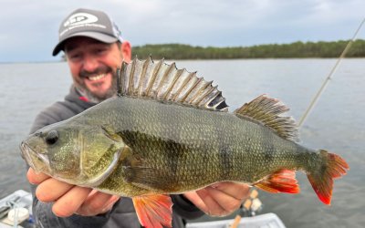
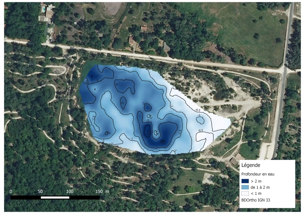
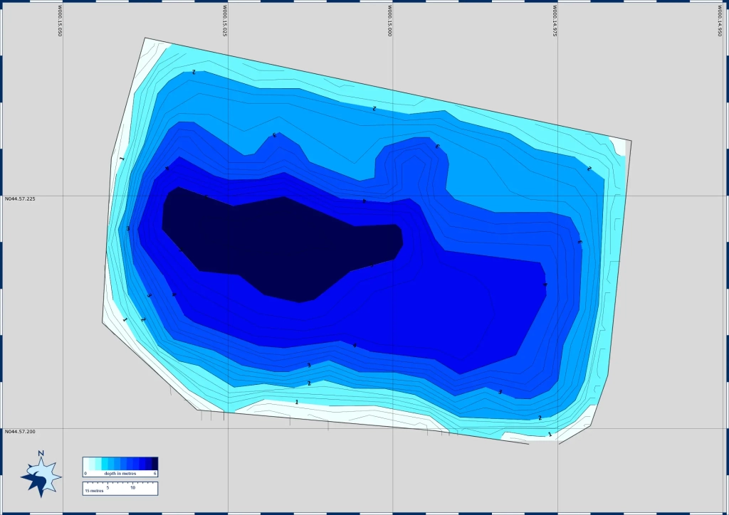
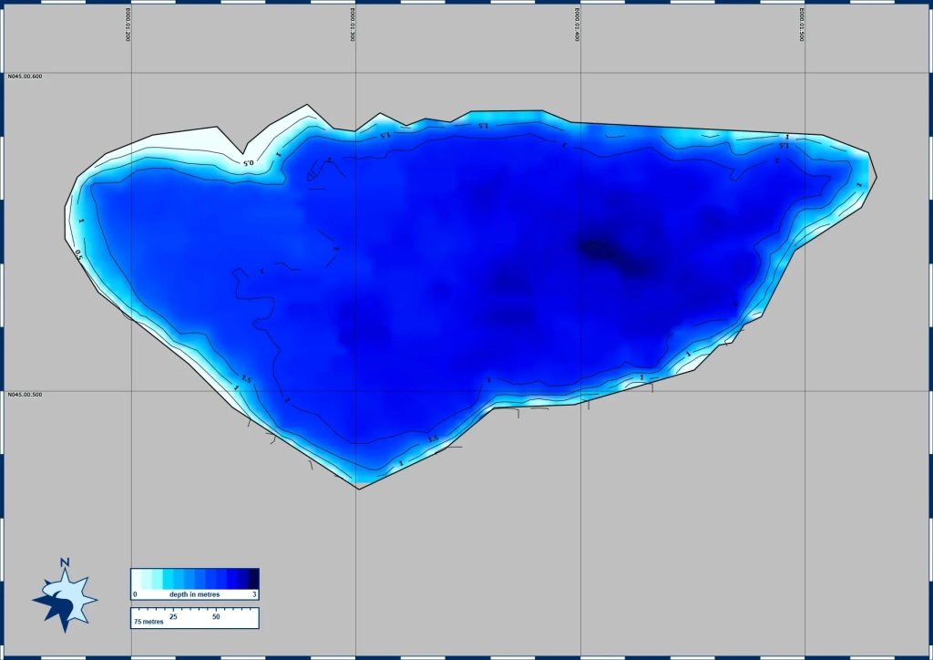
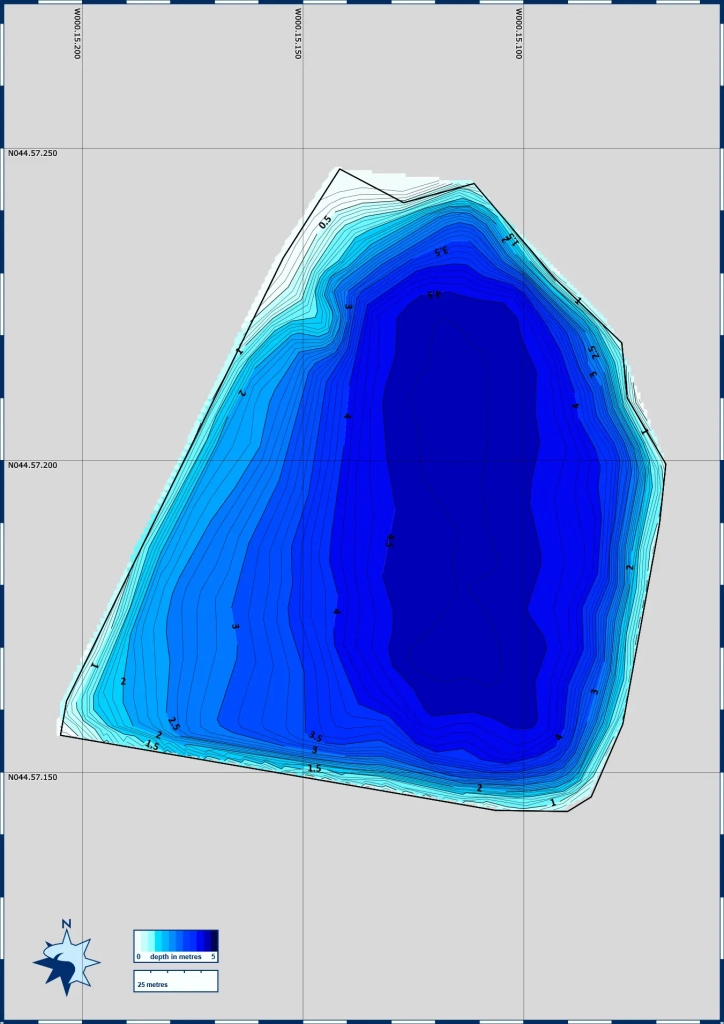
Dans le cadre de différentes missions, la Fédération de Pêche et de Protection du Milieu Aquatique de la Gironde et d’autres partenaires réalisent la bathymétrie de plans d’eau du département. En effet les profondeurs des lacs apportent de nombreuses informations sur le fonctionnement, l’état de ces milieux et notamment sur leur utilisation par la faune aquatique. C’est également des renseignements intéressants pour la pratique de la pêche.
Nous en avons réalisé 6 nouvelles : Étang de Tourenne(St-Germain-de-la-Rivière), Étang de Coutant la Roubine nord (Villenave d’Ornon), Lac de Marotte (Blanquefort), Lac de la Motte (Bruges), Lac de Cap de Bos, l’Isle (Coutras et Abzac)
Nous mettons à votre disposition l’ensemble des bathymétries disponibles à notre connaissance sur les lacs de Gironde !
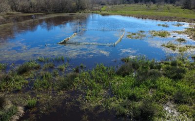
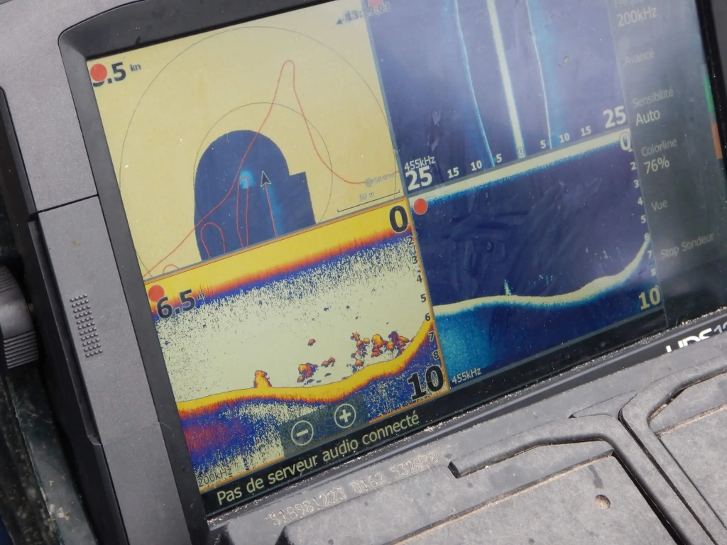
Depuis 2009, les bathymétries des parcours suivants ont été relevées à partir d’échosondeur ou de relevés manuels (sondage régulier avec une mire graduée).
La bathymétrie en 1 clic !
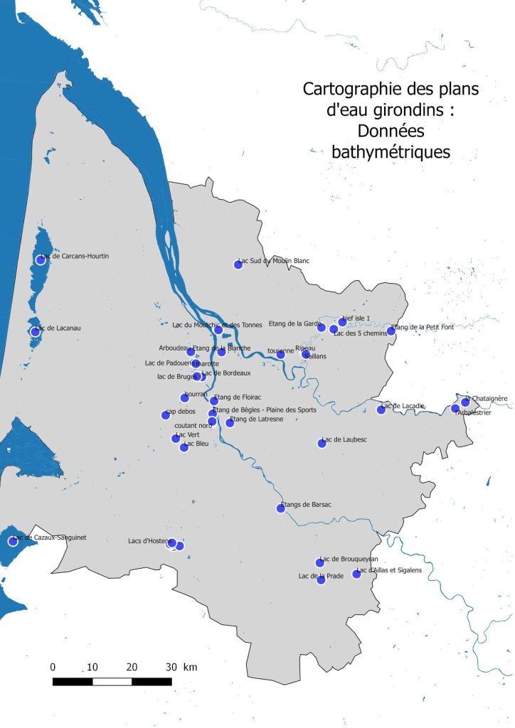
Les bathymétries des plans d’eau autour de la ville de Bordeaux :
>> Lac de Bordeaux
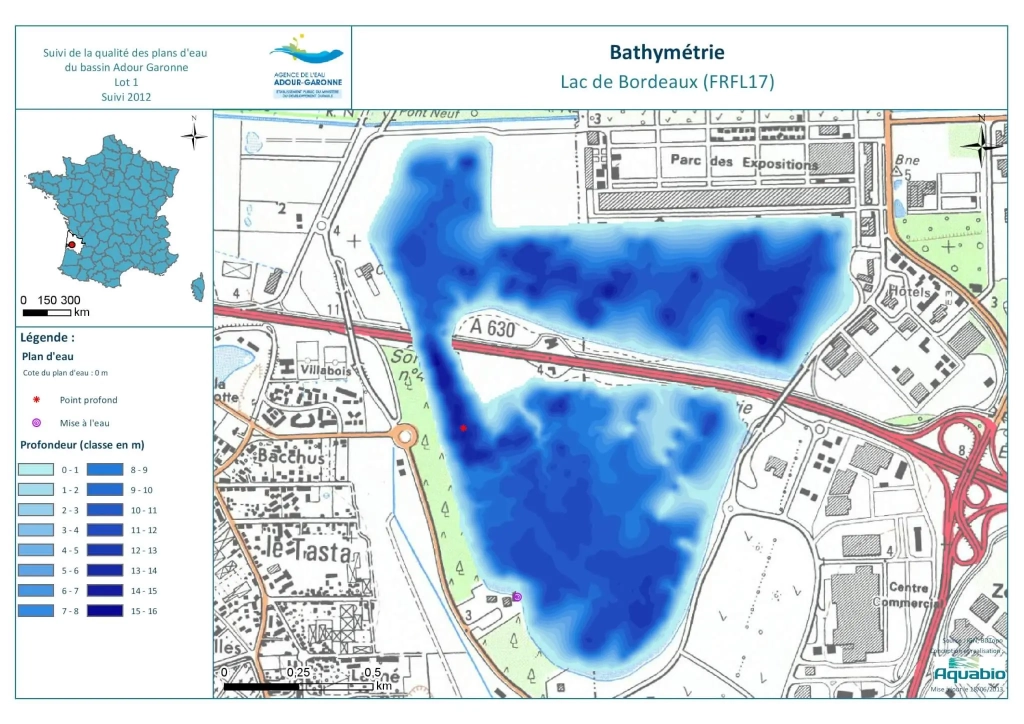
Carte d’identité :
>> Surface : 142 ha
>> Profondeur max : 15,5 m
>> Pour aller plus loin :
⇒ http://adour-garonne.eaufrance.fr/upload/DOC/FICHES/LACS/DIAG/O97-4003_diag2012.pdf
⇒ http://adour-garonne.eaufrance.fr/data/ficheSTQL?stql=O97-4003&panel=desc
>> Etang de Bègles / Plaine des Sports
Carte d’identité :
>> Surface : 7 ha
>> Profondeur max : 9.5 m
>> Etang de Floirac
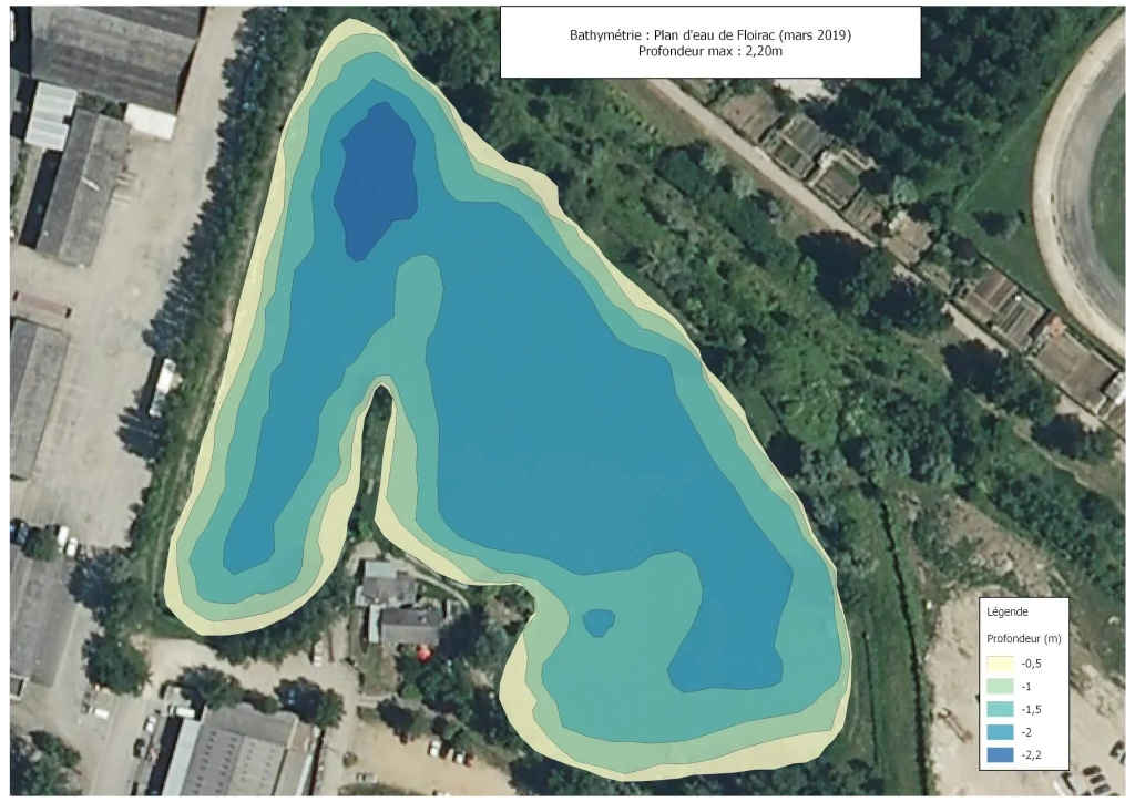
Carte d’identité :
>> Surface : 3.4 ha
>> Profondeur max : 2.6m m
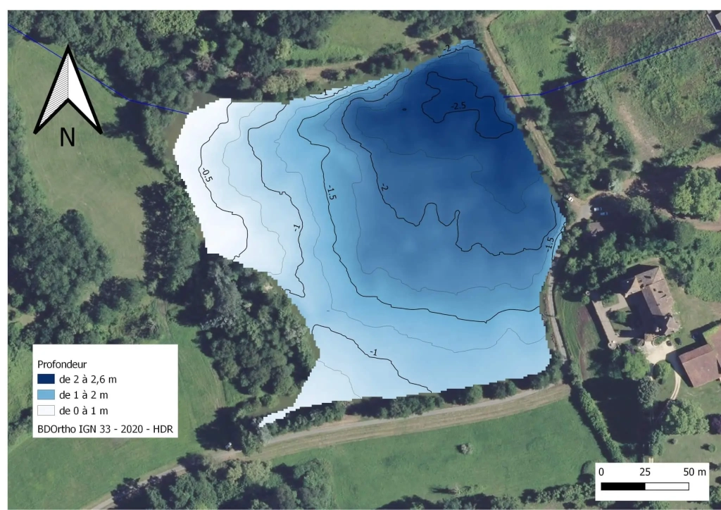
>> Etang des Sources à Latresne
Carte d’identité :
>> Surface : 1 ha
>> Profondeur max : 2.6 m
>> Profondeur moyenne : 1.75 m
>> Etang du Moutchic Cantefrêne à Ambès

Carte d’identité :
>> Surface : 9 ha
>> Profondeur max : 9.1 m
>> Profondeur moyenne : 5.4 m
>> Pour aller plus loin :
⇒ http://adour-garonne.eaufrance.fr/data/ficheSTQL?stql=—-1543&panel=desc
>> Lac des Tonnes à Ambès
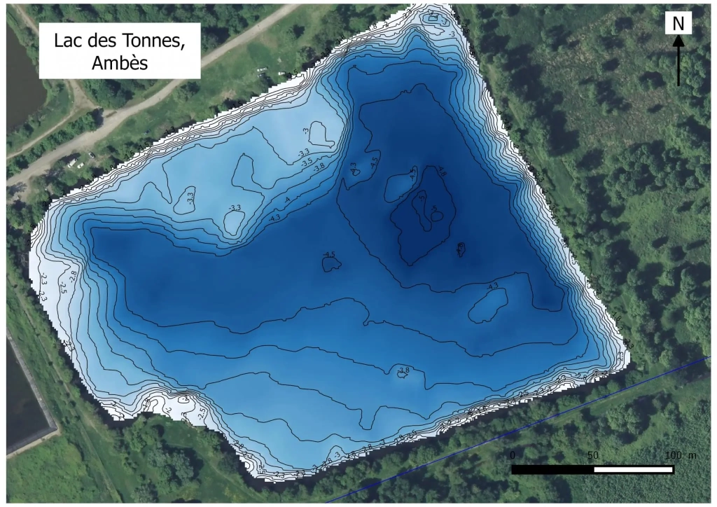
Carte d’identité :
>> Surface : 7 ha
>> Profondeur max : 5.2 m
>> Etang d’Arboudeau à Parempuyre
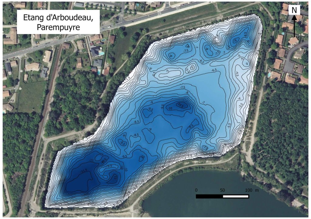
Carte d’identité :
>> Surface : 9 ha
>> Profondeur max : 11.8 m
>> Lac Vert à Canéjan

Carte d’identité :
>> Surface : 7 ha
>> Profondeur max : 7.9 m
>> Profondeur moyenne : 3
>> Lac Bleu à Léognan
Carte d’identité :
>> Surface : 2.6 ha
>> Profondeur max : 2.8 m
>> Profondeur moyenne : 1.5 m
>> Lac de Padouens à Blanquefort

Carte d’identité :
>> Surface : 24.3 ha
>> Profondeur max : 13.5 m
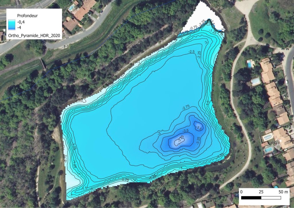
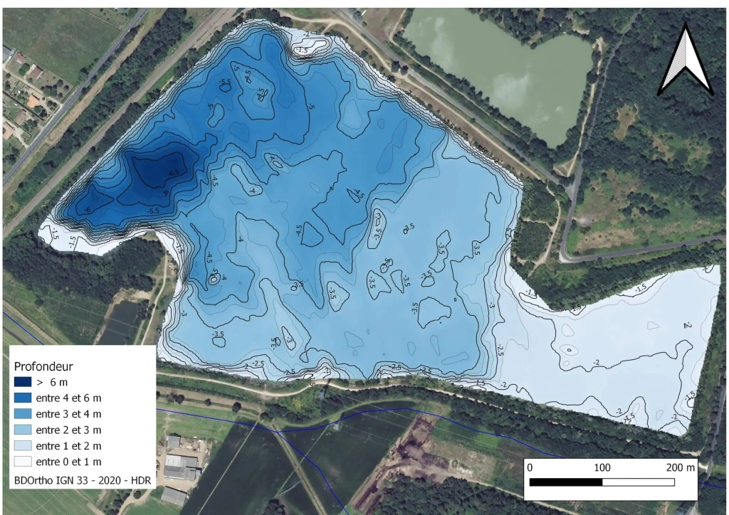
>> Lac de Marotte à Blanquefort
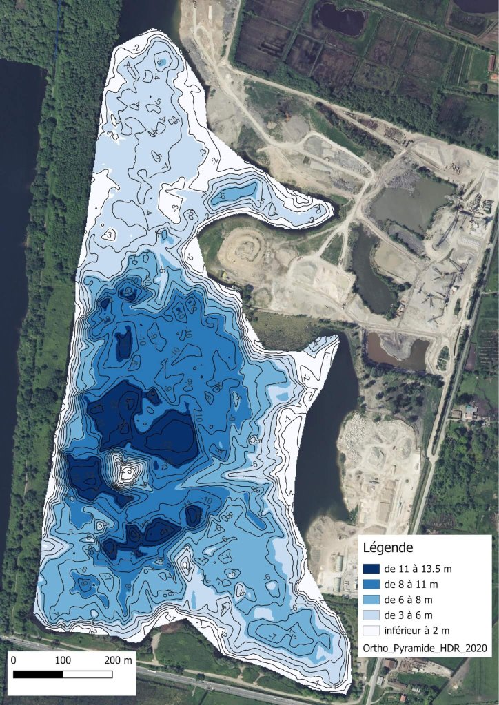
Carte d’identité :
>> Surface : 51 ha
>> Profondeur max : 13.5 m
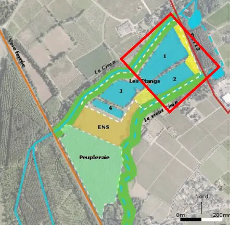
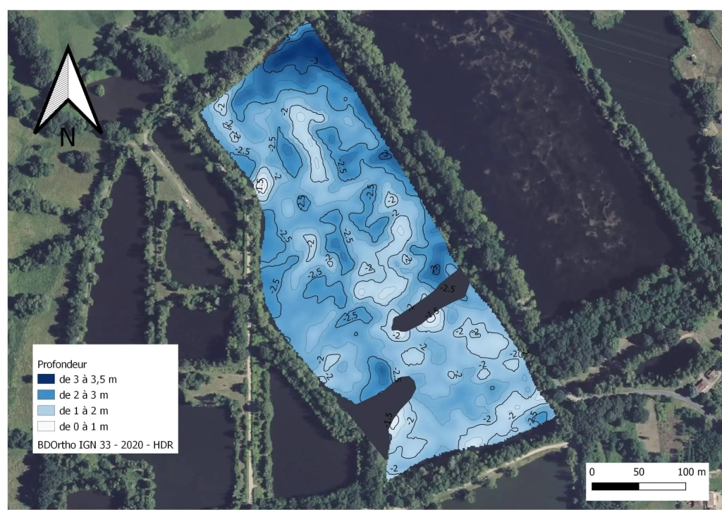
>> Etangs de Coutant la Roubine à Villenave d’Ornon (Nord et Sud)
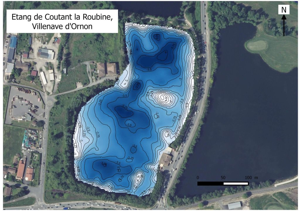
Carte d’identité :
>>Surface : 3,6ha et 5.8 ha
>> Profondeur max : 8,7m et 4.2 m
>> Grand étang de la Blanche à Ambarès-et-Lagrave
Carte d’identité :
>> Surface : 32.6 ha
>> Profondeur max : 7 m
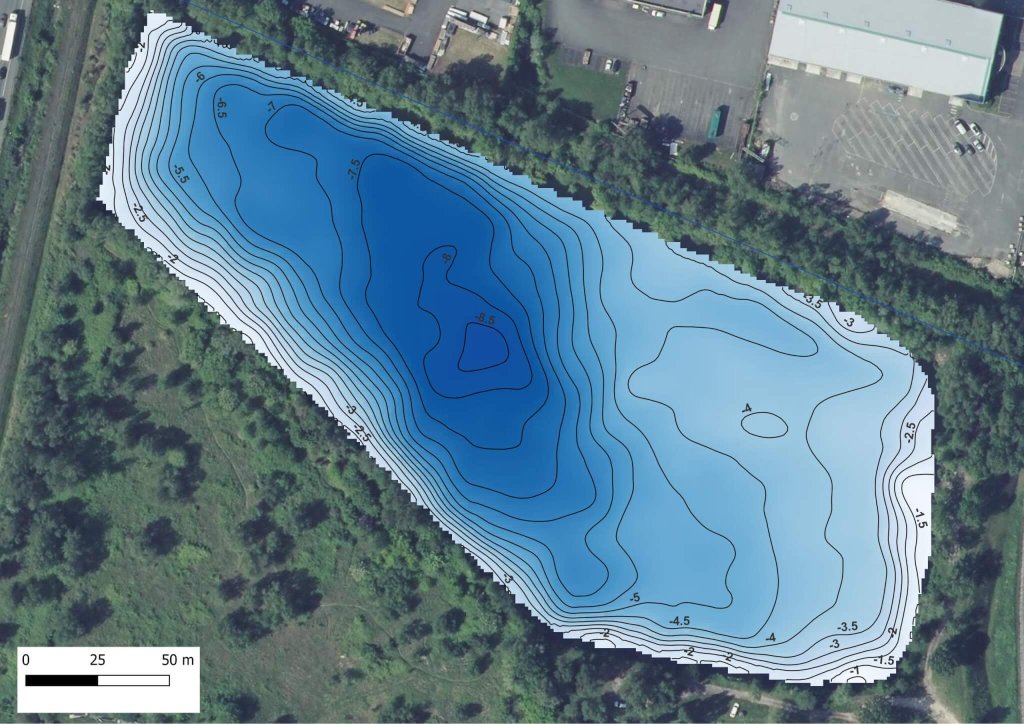
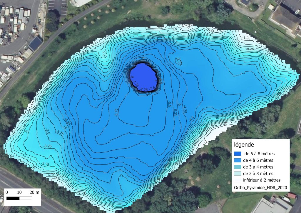
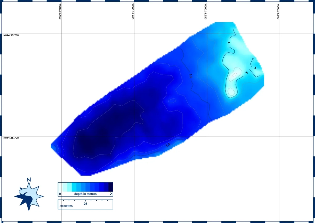
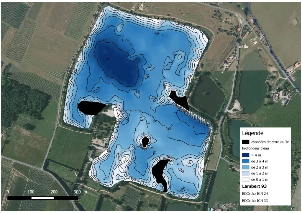
>> Lac de Cap de Bos à Pessac
Carte d’identité :
>> Surface : 4,2 ha
>> Profondeur max : 3,75 m
>> Lac de la Motte à Bruges
Carte d’identité :
>> Surface : 2 ha
>> Profondeur max : 8 m
Les bathymétries des plans d’eau du Sud Gironde et autour du Bassin d’Arcachon
>> Lac d’Aillas Sigalens
Carte d’identité :
>> Surface : 14 ha
>> Profondeur max : 8.3 m
>> Profondeur moyenne : 3.4 m
>> Pour aller plus loin :
⇒ http://adour-garonne.eaufrance.fr/data/ficheSTQL?stql=O9405003&panel=desc
>> Lac de Brouqueyran
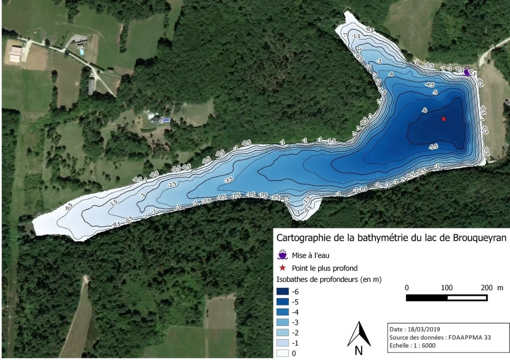
Carte d’identité :
>> Surface : 18 ha
>> Profondeur max : 6.6 m
>> Profondeur moyenne : 3.4 m
>> Pour aller plus loin :
⇒ http://adour-garonne.eaufrance.fr/data/ficheSTQL?stql=O9425003&panel=desc
⇒ http://adour-garonne.eaufrance.fr/data/ficheSTQL?stql=O9425003&panel=desc
>> Les étangs 1 et 2 sur Barsac
Carte d’identité :
>> Surface :
→ 2.5 ha pour le premier
→ 1.6 ha pour le deuxième
>> Profondeur max : 2 m

>> Lac de la Prade
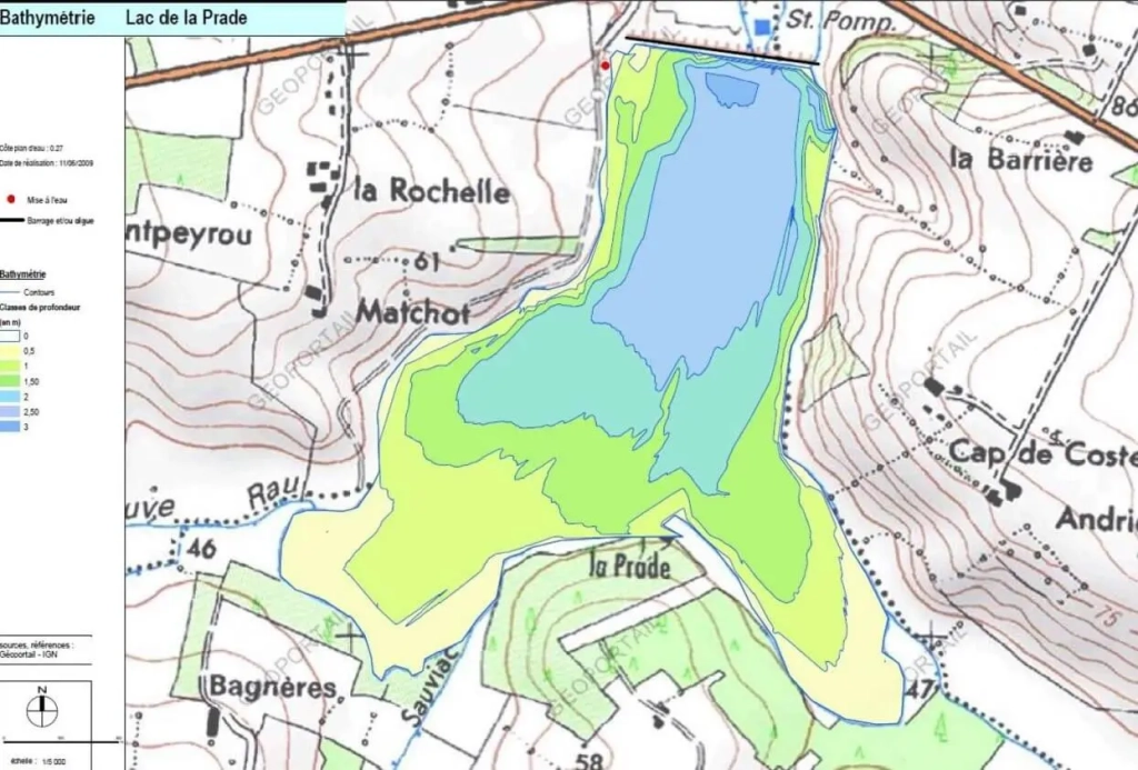
Carte d’identité :
>> Surface : 60 ha
>> Profondeur max : 3.1 m
>> Pour aller plus loin :
⇒ http://adour-garonne.eaufrance.fr/upload/DOC/FICHES/LACS/DIAG/O9415013_diag2009.pdf
⇒ http://adour-garonne.eaufrance.fr/data/ficheSTQL?stql=O9415013&panel=desc
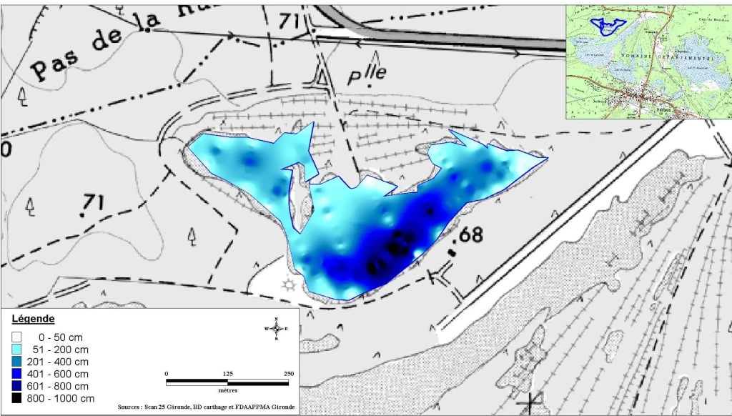
>> Les lacs d’Hostens
Petit Bernadas
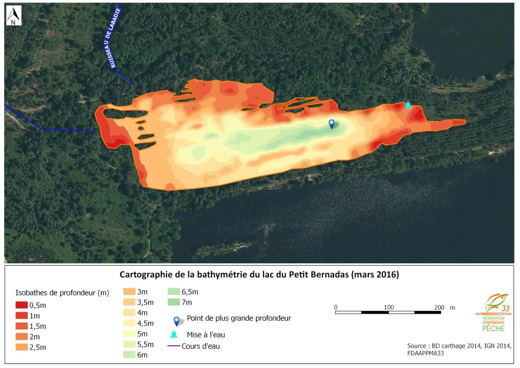
Carte d’identité :
>> Surface : 9 ha
>> Profondeur max : 8.1 m
>> Profondeur moyenne : 3.7 m
>> Pour aller plus loin :
⇒ http://adour-garonne.eaufrance.fr/data/ficheSTQL?stql=S2245043&panel=desc
→ Grand Bernadas
Carte d’identité :
>> Surface : 11 ha
>> Profondeur max : 10 m
>> Profondeur moyenne : 3.8 m
→ Lamothe
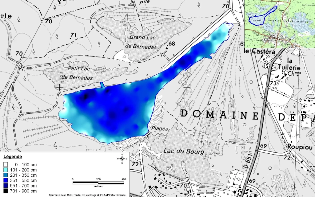
Carte d’identité :
>> Surface : 34 ha
>> Profondeur max : 8.7 m
>> Profondeur moyenne : 4.1 m
→ Bourg
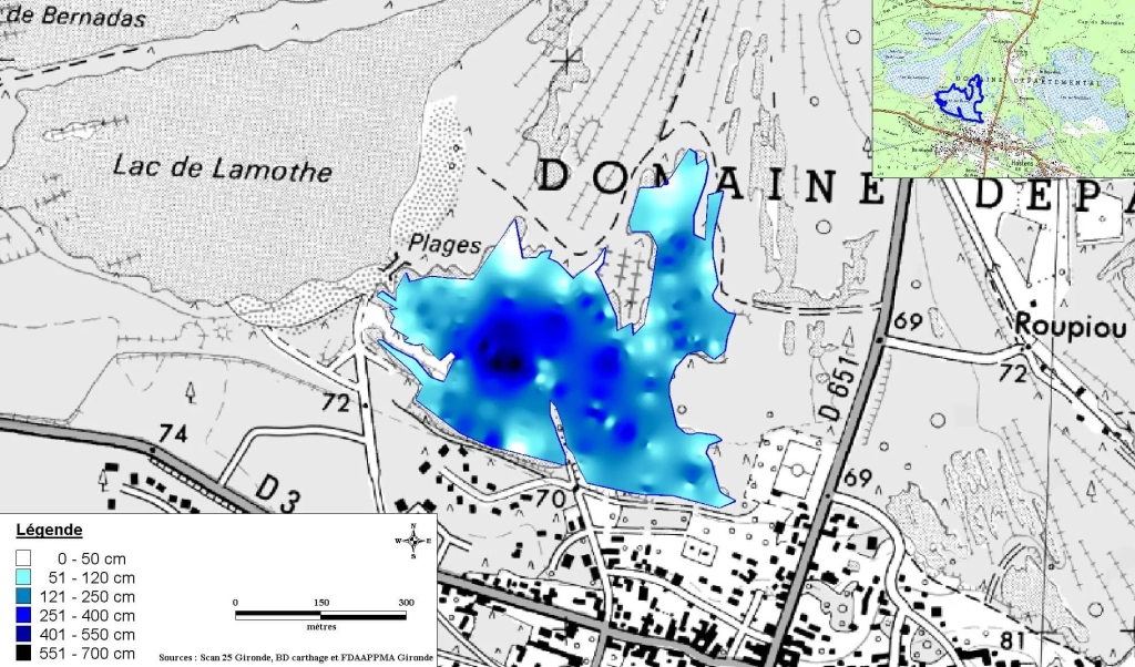
Carte d’identité :
>> Surface : 18 ha
>> Profondeur max : 6.7 m
>> Profondeur moyenne : 2.3 m
→ Bousquet
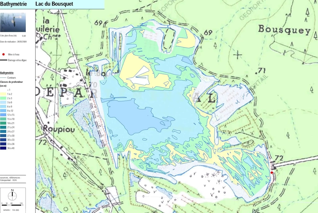
Carte d’identité :
>> Surface : 66.8 ha
>> Profondeur max : 8.2 m
>> Pour aller plus loin :
⇒ http://adour-garonne.eaufrance.fr/upload/DOC/FICHES/LACS/DIAG/O9645133_diag2009.pdf
⇒ http://adour-garonne.eaufrance.fr/data/ficheSTQL?stql=O9645133&panel=desc
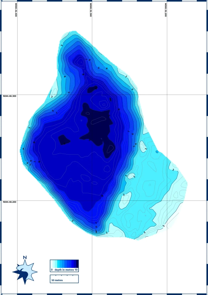
>> Lac de Cazaux-Sanguinet

Carte d’identité :
>> Surface : 5 800 ha
>> Profondeur max : 22.9 m
>> Pour aller plus loin :
⇒ http://adour-garonne.eaufrance.fr/upload/DOC/FICHES/LACS/DIAG/S3025003_diag2016.pdf
⇒ http://adour-garonne.eaufrance.fr/data/ficheSTQL?stql=S3025003&panel=desc
Les bathymétries des plans d’eau du Libournais et du Blayais
>> Lac sud Moulin Blanc à Saint Christoly de Blaye
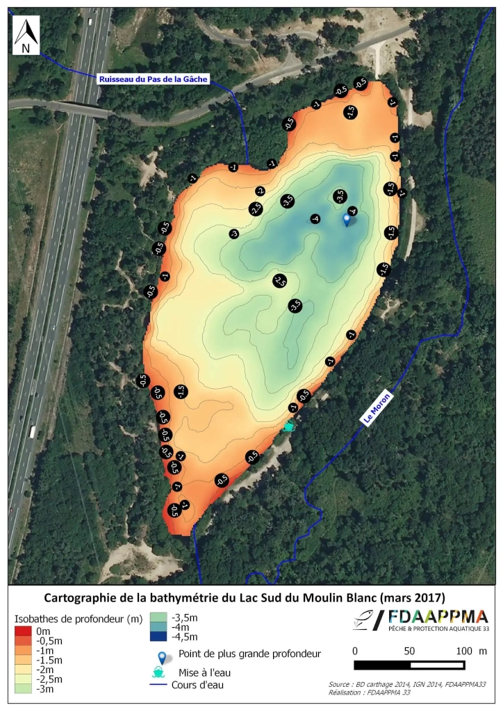
Carte d’identité :
>> Surface : 6.3 ha
>> Profondeur max : 4.3 m
>> Profondeur moyenne : 2.3 m
>> Pour aller plus loin :
⇒ http://adour-garonne.eaufrance.fr/data/ficheSTQL?stql=P9115003&panel=desc
>> Etang de Ripeau
Carte d’identité :
>> Surface : moins d’1 ha
>> Profondeur max : 6 m
>> Etang de la Petite Font
Carte d’identité :
>> Surface : 6.6 ha
>> Profondeur max : 3 m
>> Etang de Saillans
Carte d’identité :
>> Surface : 2.5 ha
>> Profondeur max : 5.3 m
>> Lac des 5 chemins à Abzac
Carte d’identité :
>> Surface : 27.5 ha
>> Profondeur max : 6.7 m
>> Etang de la Garde (chèvres) à St Denis de Pile
Carte d’identité :
>> Surface : 8 ha
>> Profondeur max : 3.5 m
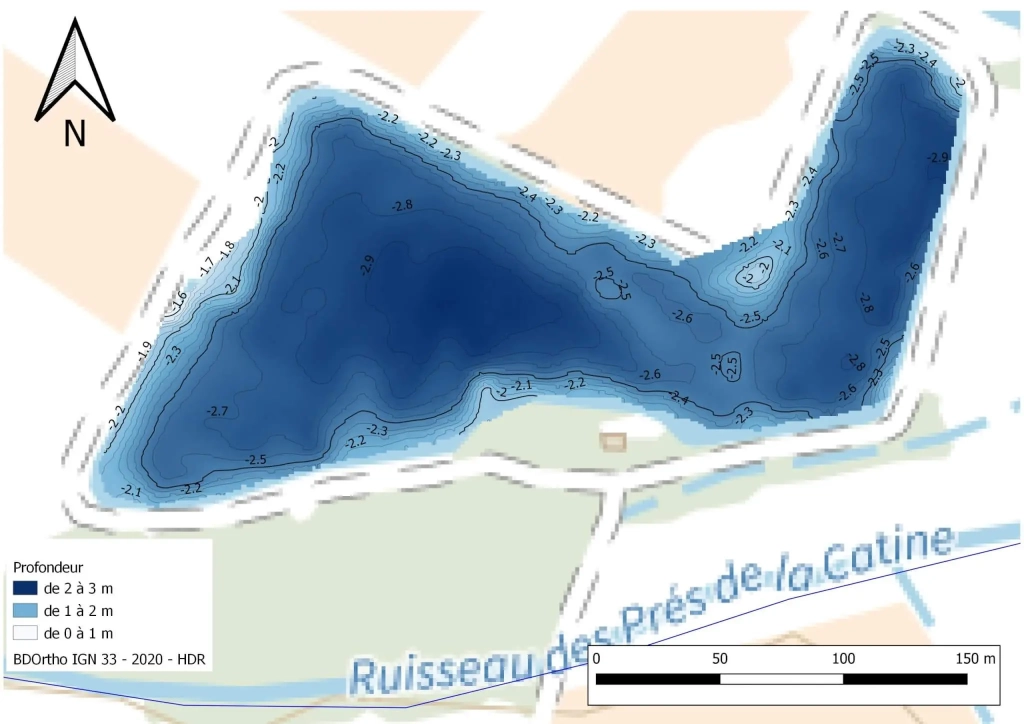
>> Lac des Dagueys à Libourne
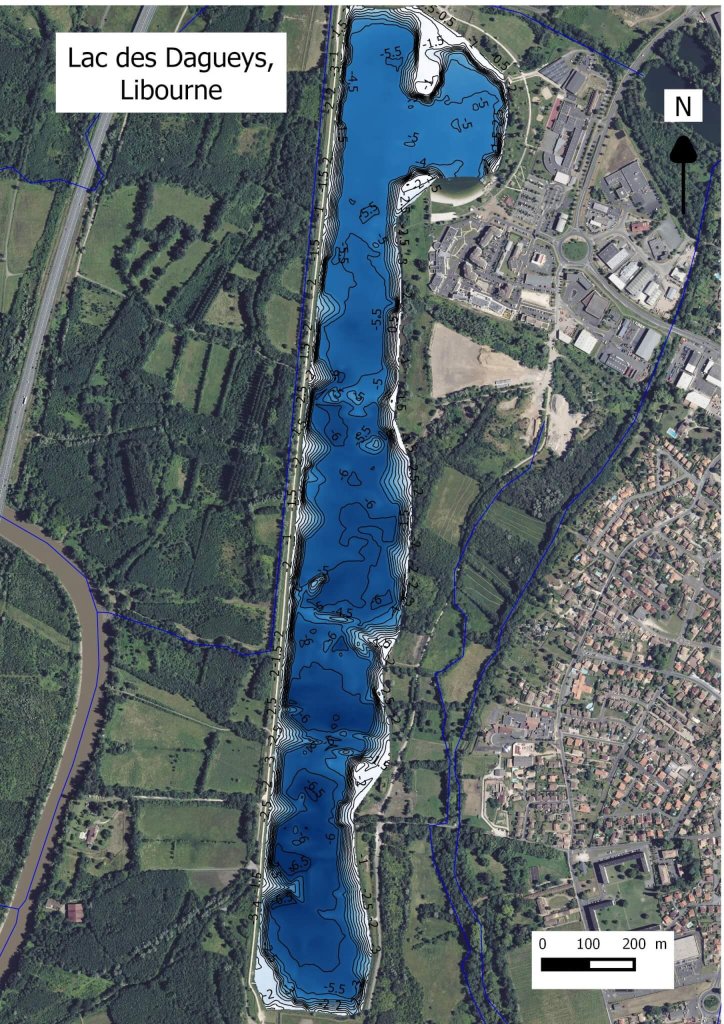
Carte d’identité :
>> Surface : 49 ha
>> Profondeur max : 6.7 m
>> Étang de Tourenne à St-Germain-de-la-Rivière
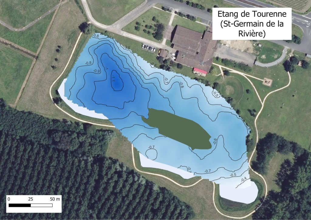
Carte d’identité :
>> Surface : 1,8 ha
>> Profondeur max : 1,15 m
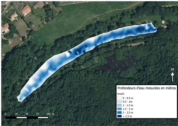
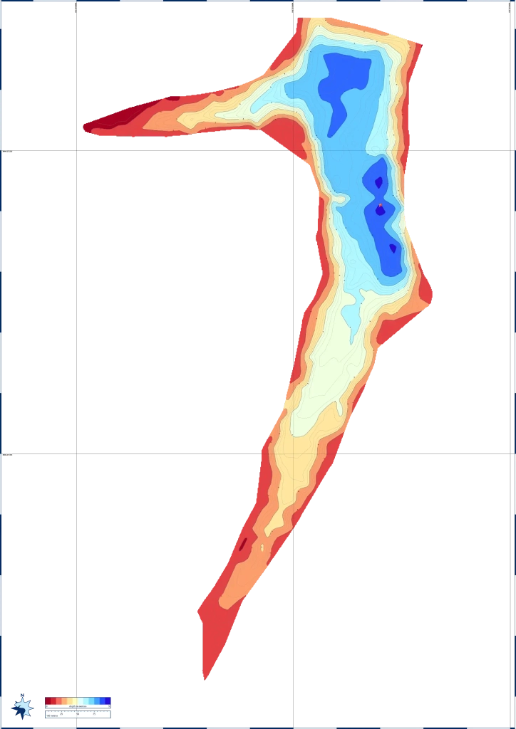
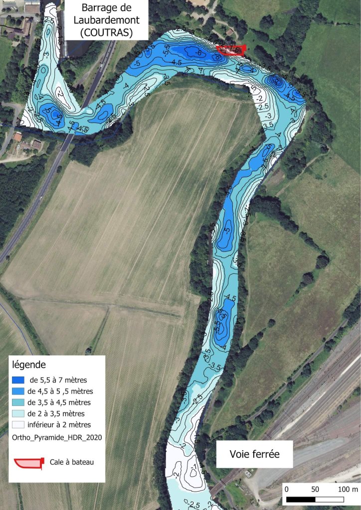
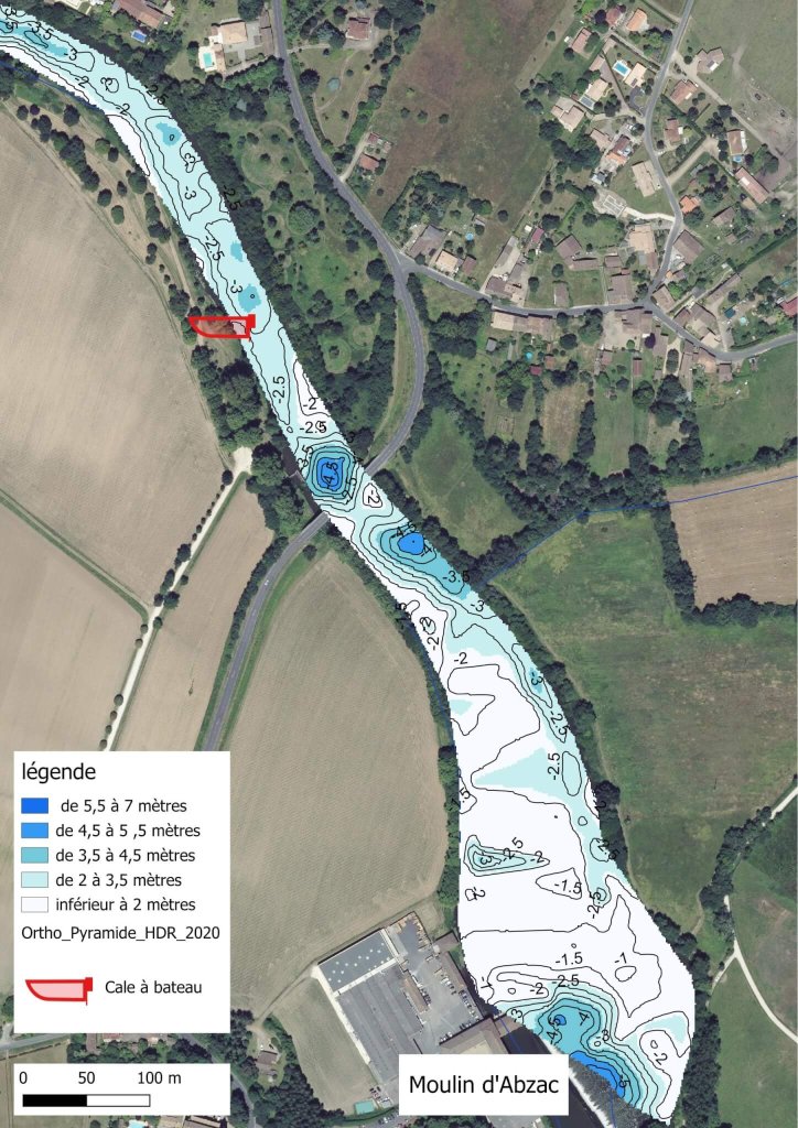
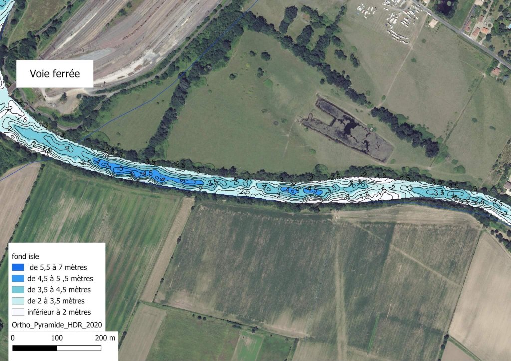
>> L’Isle à Coutras et Abzac
Les bathymétries des plans d’eau de l’Entre-Deux-Mers
>>Lac de la Cadie à Mouliets-et-Villemartin
Carte d’identité :
>> Surface : 36.3 ha
>> Profondeur max : 5.3 m
>> Profondeur moyenne : 3.3 m
>> Etang de Laubesc à Cessac
Carte d’identité :
>> Surface : 3.4 ha
>> Profondeur max : 2.6 m
>> Etang de l’Arbalestrier à Pineuilh

Carte d’identité :
>> Surface : 4 ha
>> Profondeur max : 3.7 m
>> Etang de la Châtaignière à St Avit St Nazaire
Carte d’identité :
>> Surface : 3.5 ha
>> Profondeur max : 3 m
Les bathymétries des plans d’eau du Médoc
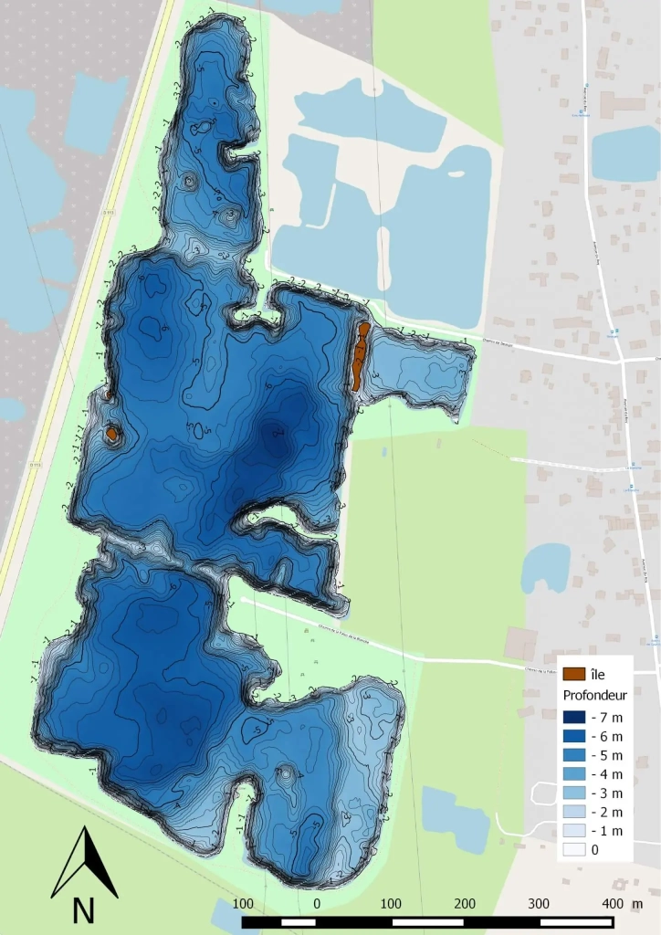
>>Lac de Carcans-Hourtin
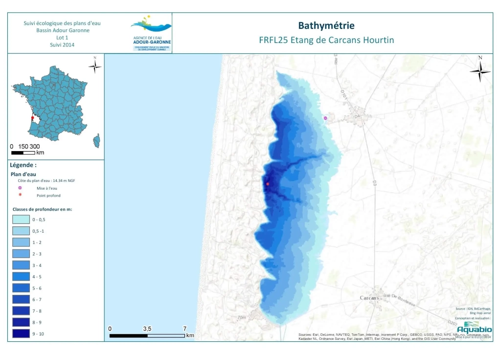
Carte d’identité :
>> Surface : 5816 ha
>> Profondeur max : 9.7 m
>> Pour aller plus loin :
⇒ http://adour-garonne.eaufrance.fr/data/ficheSTQL?stql=S1205023&panel=desc
⇒ http://adour-garonne.eaufrance.fr/upload/DOC/FICHES/LACS/DIAG/S1205023_diag2016.pdf
>> Lac de Lacanau
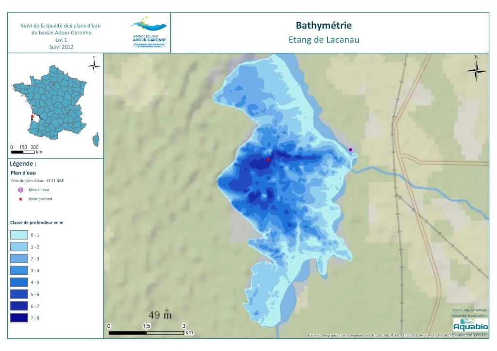
Carte d’identité :
>> Surface : 1620 ha
>> Profondeur max : 7.3 m
>> Pour aller plus loin :
⇒ http://adour-garonne.eaufrance.fr/data/ficheSTQL?stql=S1215013&panel=desc
⇒ http://adour-garonne.eaufrance.fr/upload/DOC/FICHES/LACS/DIAG/S1215013_diag2016.pdf